Lansing, MI 48911

Population 40,732

48911 is zip code located in Lansing, Michigan. The population is 40,732, making 48911 the largest zipcode in Lansing and the largest in Eaton County.

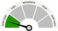
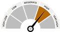
There are 12 public schools in 48911 with an average Homefacts rating of D+. The total crime rate for Lansing is high , and there are 170 registered sex offenders residing in the zip code 48911. Unemployment in 48911 is high.

Zip codes within Lansing include 48901, 48906 and 48907.

Lansing Neighborhood Report

Schools

School Rating is Below Average

Crime Rate

36.23% Higher than national avg.

Registered Offenders

67.56% Higher than national avg.

Environmental Hazards

100 Found nearby

Unemployment

High 6.6%

Property Values

Median Property Value $0

Schools view all

12 Public Schools view public schools

Summary
There are 12 K-12 public schools in 48911, MI and 1 private school. Homefacts rates 48911's schools as Below Average, with an overall D+ rating.
  • School District Rating
  • We're sorry! No School District is found our database.
1 Private School

Lansing Christian School

view 1 private school

1 Colleges & Universities view all colleges & universities

View All School Information

Crime view details

170 Registered Offenders search the registered offender database


  • 4210 INGHAM ST LANSING MI 48911


  • 1217 VICTORIA DR LANSING MI 48911


  • 3700 STILLWELL AVE LANSING MI 48911


  • 6112 MARYWOOD AVENUE LANSING MI 48911


  • 6941 CALSON DR LANSING MI 48911


  • 5715 S WAVERLY RD LANSING MI 48911


  • 6015 CHESAPEAKE DR LANSING MI 48911


  • 4821 RICHMOND ST LANSING MI 48911


  • 1100 RAMADA DRIVE LANSING MI 48911


  • 116 W MILLER LANSING MI 48911

View All Registered Offenders

Crime Index view report

*100 is national avg. Greater than 100 means higher crime, lower means less crime.
  • Total Crime Index
  • Violent Crime Index
  • Property Crime Index

Property Reports view all

Property Report Overview

Housing Inventory

Property Type
  • Vacant
    12.2%
  • Rented
    43.2%
  • Owned
    44.7%

14 Building Permits View All

  • In 2014, the city of Lansing, MI issued 14 building permits. All permits issued were for Single Family Homes. All permits issued were for Single Family Homes.
  • In 2013, the city of Lansing, MI issued 182 building permits. All permits issued were for Single Family Homes. Of those 182 permits, 36 were issued for single family homes and 146 were issued for multi-family homes.
All Housing Single Family Housing Multi-Family Housing

Building Permits By Year

Fair Market Rents

**Displaying data from MI 48911
  • Property Type Rent
  • Studio: $670
  • 1 Bedroom: $700
  • 2 Bedrooms: $850
  • 3 Bedrooms: $1,090
  • 4 Bedrooms: $1,150

View All Property Reports

Environmental Hazards

100 Environmental Hazards

  • Brownfields
    in Lansing, MI
    view all
  • Registered Polluters
    in Lansing, MI
    view all
  • Superfunds
    in Lansing, MI
    view all
  • Tanks & Spills
    in Lansing, MI
    view all

Health Hazards

  • Air Quality HEALTHY (261/283)
    Lansing, MI has 92.23% good air quality.
    view all
  • Radon ZONE 2 COUNTY
    Lansing, MI is a yellow zone.
    view all
  • UV Index MODERATE 3.82 Average
    Lansing, MI is a moderate risk area for ultra-violet rays.
    view all

Weather

  • We're sorry! No Weather statistics found in our database.

Average Monthly Temperature

  • January 23.2°
  • February 25.6°
  • March 36.95°
  • April 47.65°
  • May 59.5°
  • June 68.1°
  • July 73°
  • August 70.3°
  • September 62.4°
  • October 51.12°
  • November 40.22°
  • December 29.02°

View More About Environmental Hazards

Natural Disasters

Probability of Natural Disasters for Lansing, MI

Earthquakes
Lansing, MI has a very low risk of earthquakes.
Hurricanes
Lansing, MI has no risk of hurricanes.
Hail
Lansing, MI has a low risk of hail storms.
Tornadoes
Lansing, MI has a high risk of tornadoes.

Demographics view details

Median Household Income

Median Household Income in 48911: $39,522

Unemployment

Unemployment in Lansing is 6.6%. It is lower than the state and national averages, 4.0% and 7.7% respectively

Workforce Breakdown

Blue Collar - 46.43%
White Collar - 53.57%

Politics

State Representatives

  • Gov. Rick Snyder
  • Sen. Gary Peters
  • Sen. Debbie Stabenow

City Representatives

  • Tim Walberg
  • Mike Bishop

Neighborhood Info

0 Airports view all

Nearest Major Airports

0 Cemeteries view all

  • We're sorry! No cemeteries found for 48911 in our database.

8 FCC Towers view all

0 Fire Stations view all

  • We're sorry! No fire stations found for 48911 in our database.

0 Hospitals view all

  • We're sorry! No hospitals found for 48911 in our database.

0 Libraries view all

  • We're sorry! No libraries found for 48911 in our database.

0 Police Stations view all

  • We're sorry! No police stations found for 48911 in our database.