70121 is zip code located in New Orleans, Louisiana. The population is 11,945.
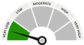
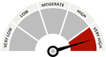
There are 0 public schools in 70121 with an average Homefacts rating of B-. The total crime rate for New Orleans is very high , and there are 31 registered sex offenders residing in the zip code 70121. Unemployment in 70121 is very high.
Zip codes within New Orleans include 70112, 70113 and 70114.